Trunk sewer under Canal Street commercial fill
Deep gravity line with tight tolerance — shafts replace trench through shallow Xcel and fiber congestion.
Carlsbad, NM · Eddy County
Microtunneling for Carlsbad municipal trunks and Pecos River outfalls — pipe jacking when HDD cannot hold gravity grade in flood-control fill.
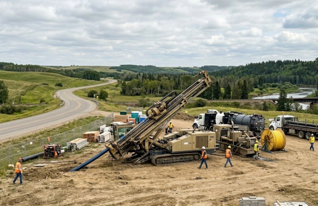
Tunneling and TBM work in Carlsbad targets deep gravity sewer, large storm outfalls, and specs where steerable HDD cannot meet diameter or elevation tolerance along Canal Street utility fill. Shaft spreads concentrate impact versus open trenching trunk lines through downtown.
Pecos River outfall and flood-control projects often land here — high groundwater and settlement limits push engineers toward pipe jacking instead of wide open cuts through river-adjacent trail systems.
Residential laterals and short commercial shots stay on HDD. Microtunneling in Carlsbad is municipal-scale work — we scope shafts, slurry handling, and city inspection milestones when plans call for it.
Real Eddy County angles — not generic statewide copy.
Deep gravity line with tight tolerance — shafts replace trench through shallow Xcel and fiber congestion.
Floodplain permits and bank stability favor mined crossing with engineered shafts over open cut in wet alluvium.
RCP jacking on laser guidance with settlement monitoring adjacent to potash-service spurs.
NMDOT-adjacent storm trunk — shaft-to-shaft mining when lane closure math beats open cut.
Carlsbad microtunneling starts with shored, dewatered shafts surveyed to city hold points. Steering head mines the face; pipe jacks behind on laser grade. Slurry handling matches Pecos-adjacent groundwater; inspection follows municipal contract milestones.
Eddy County Delaware Basin fringe carries gypsum-rich soil, caliche hardpan, and Pecos River alluvium — potash-mine grading debris and brine-infrastructure proximity change mud programs mile to mile.
Carlsbad bores encounter gypsum-rich sandy loam on mesa parcels with caliche hardpan between 2 and 8 feet — similar to Roswell valley fill but with more Pecos River alluvium near the watercourse. Potash-mine service corridors can hide grading cobbles and brine-infrastructure debris that potholing catches before pits are sized. River-adjacent paths carry higher groundwater after Pecos flood stages and monsoon storms — buoyancy management matters on longer HDPE pulls. We do not assume Hobbs open-desert models apply along the Pecos corridor.
Pecos River valley heat, spring wind, and summer monsoons drive Carlsbad bore schedules — river-adjacent groundwater and potash-brine corridor awareness are built into quotes.
Summer heat above 100°F affects crew safety and fluid performance on exposed valley pads. Pecos River flood stages in spring and monsoon cloudbursts from July through September raise river-adjacent groundwater — entry pit work may wait for stable conditions. Spring wind complicates cage handling on open US-285 sites. We schedule around known flood patterns instead of forcing bores into saturated Pecos bank fill.
City of Carlsbad Community Development, Eddy County ROW, NMDOT District 2 on US-285 and US-62, Pecos River floodplain, potash operator easements, and Xcel Energy agreements apply on many alignments.
City of Carlsbad Community Development governs street cuts, driveway removals, and flood-control work along the Pecos River and municipal drainage. Eddy County ROW applies on unincorporated parcels toward Loving and the Caverns approach. NMDOT District 2 controls US-285, US-62, and National Parks Highway bores — MOT plans are common on Canal Street frontage. Pecos River floodplain review adds environmental hold points beyond standard 811. Potash operator and brine-infrastructure easements govern mine-adjacent paths. Xcel Energy agreements apply on electric-adjacent corridors.
Open trunk trench through Canal retail strips hits storefront access and shallow utilities. Shafts localize disruption. HDD rarely replaces microtunneling on large gravity sewer with strict municipal tolerance.
Diameter, length, shaft depth, groundwater handling, disposal, guidance, and municipal inspection milestones.
You share plans or describe the problem; we confirm alignment, depth, access, and which trenchless method fits New Mexico soils.
New Mexico 811 ticket filed; two business days minimum before pits open unless your permit path differs. We pothole where marks conflict.
Bore plan, NMDOT or city ROW permits, railroad agreements, and crossing engineering when the path leaves private property.
Compact spread for tight Santa Fe lots; larger HDD for I-25 or I-40 relocations — matched to length and diameter.
Steered pilot on design line, ream passes sized for your pipe or casing, fluid program tuned for caliche or adobe clay.
HDPE fusion, steel casing, or multi-duct bundle pulled with tension and bend-radius monitoring.
Pressure test, mandrel, or survey records for owners, inspectors, and operators as spec requires.
Compact pits, replace gravel or hardscape per scope, leave 811 ticket and locate map in your project file.
Large gravity sewer, tight grade, or sealed-face spec in plans — method stays with engineer approval.
Shafts are smaller than a full trunk trench but still need traffic control and gravel restoration.
We coordinate with your engineer for shaft, mining, and reception hold points per contract.
Rarely — short laterals use HDD. Trunk scale justifies shaft spreads.
24/7 — Emergency dispatch statewide. Tell us entry, exit, pipe size, and county — a bore specialist calls back with cost drivers, not a flat rate.
Scope your alignment
Step 1 of 2 — path, pipe, and city first