Lateral under a North Carlsbad courtyard walk
Gypsum soil and aging PVC failed under stucco walls — HDD from cleanout to tap preserves rock mulch and gravel.
Carlsbad, NM · Eddy County
No-dig sewer and water boring under Carlsbad gravel drives — lateral replacement when gypsum soil breaks PVC and open-cut would destroy North Carlsbad hardscape.
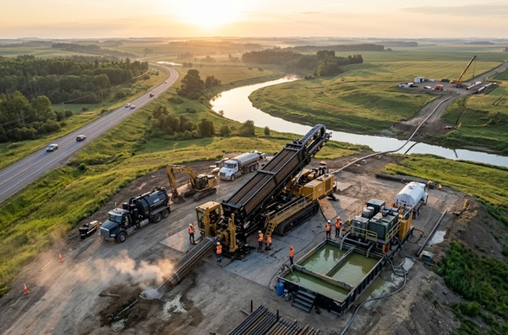
Sewer and water line boring in Carlsbad is the fix when a lateral fails under a gravel driveway or courtyard and the owner refuses full-yard restoration. Compact pits steer HDPE or PVC through valley fill without a continuous trench.
North Carlsbad subdivisions from the 1950s through 1980s are hitting first sewer replacements — camera inspection confirms breaks under circular drives. Directional boring in Carlsbad for residential work spikes after city notices and Pecos-adjacent groundwater exposes weak laterals.
Municipal lead rehab along Canal and Pierce bundles shallow laterals with main work — tap rules, pressure test, and gravel restoration follow city detail.
Real Eddy County angles — not generic statewide copy.
Gypsum soil and aging PVC failed under stucco walls — HDD from cleanout to tap preserves rock mulch and gravel.
Monsoon heave cracked PVC — bore avoids full drive removal; meter tie-in may need small cut.
City notice on aging lead — trenchless pull keeps landscaping intact.
Canal pad cannot lose stalls — night tie-in to city main when traffic is light.
Carlsbad sewer and water bores begin with camera and locate confirmation — pits sized for valley stability. Pipe pulled and tied per tap rules; testing follows city requirements. Pecos-adjacent saturated soil may delay pits — we communicate when dry conditions matter.
Eddy County Delaware Basin fringe carries gypsum-rich soil, caliche hardpan, and Pecos River alluvium — potash-mine grading debris and brine-infrastructure proximity change mud programs mile to mile.
Carlsbad bores encounter gypsum-rich sandy loam on mesa parcels with caliche hardpan between 2 and 8 feet — similar to Roswell valley fill but with more Pecos River alluvium near the watercourse. Potash-mine service corridors can hide grading cobbles and brine-infrastructure debris that potholing catches before pits are sized. River-adjacent paths carry higher groundwater after Pecos flood stages and monsoon storms — buoyancy management matters on longer HDPE pulls. We do not assume Hobbs open-desert models apply along the Pecos corridor.
Pecos River valley heat, spring wind, and summer monsoons drive Carlsbad bore schedules — river-adjacent groundwater and potash-brine corridor awareness are built into quotes.
Summer heat above 100°F affects crew safety and fluid performance on exposed valley pads. Pecos River flood stages in spring and monsoon cloudbursts from July through September raise river-adjacent groundwater — entry pit work may wait for stable conditions. Spring wind complicates cage handling on open US-285 sites. We schedule around known flood patterns instead of forcing bores into saturated Pecos bank fill.
City of Carlsbad Community Development, Eddy County ROW, NMDOT District 2 on US-285 and US-62, Pecos River floodplain, potash operator easements, and Xcel Energy agreements apply on many alignments.
City of Carlsbad Community Development governs street cuts, driveway removals, and flood-control work along the Pecos River and municipal drainage. Eddy County ROW applies on unincorporated parcels toward Loving and the Caverns approach. NMDOT District 2 controls US-285, US-62, and National Parks Highway bores — MOT plans are common on Canal Street frontage. Pecos River floodplain review adds environmental hold points beyond standard 811. Potash operator and brine-infrastructure easements govern mine-adjacent paths. Xcel Energy agreements apply on electric-adjacent corridors.
Gravel drives and rock mulch cost more to replace than trench in an empty lot — boring wins where restoration is the pain point.
Length, depth, tap fees, rock, paver restoration, and access for rig staging.
You share plans or describe the problem; we confirm alignment, depth, access, and which trenchless method fits New Mexico soils.
New Mexico 811 ticket filed; two business days minimum before pits open unless your permit path differs. We pothole where marks conflict.
Bore plan, NMDOT or city ROW permits, railroad agreements, and crossing engineering when the path leaves private property.
Compact spread for tight Santa Fe lots; larger HDD for I-25 or I-40 relocations — matched to length and diameter.
Steered pilot on design line, ream passes sized for your pipe or casing, fluid program tuned for caliche or adobe clay.
HDPE fusion, steel casing, or multi-duct bundle pulled with tension and bend-radius monitoring.
Pressure test, mandrel, or survey records for owners, inspectors, and operators as spec requires.
Compact pits, replace gravel or hardscape per scope, leave 811 ticket and locate map in your project file.
Often yes when pits at logical ends allow — confirmed on site after camera and locate.
Varies by address — quote states owner, city, or contractor responsibility.
Many driveway shots finish in one to two days after valid locates. Permits or wet soil extend the window.
Sometimes — alignment must clear structures. Site walk determines feasibility.
24/7 — Emergency dispatch statewide. Tell us entry, exit, pipe size, and county — a bore specialist calls back with cost drivers, not a flat rate.
Scope your alignment
Step 1 of 2 — path, pipe, and city first