Duct bank under a Canal Street medical office pad
Post-paving TI cannot trench across the parking aisle to reach switchgear. HDD links vaults with pits offset from striping.
Carlsbad, NM · Eddy County
Steerable HDD under Carlsbad gravel drives, Canal Street pads, and NMDOT US-285 relocations — mud programs for gypsum soil, Pecos River alluvium, and potash-corridor congestion.
Horizontal directional drilling in Carlsbad serves North Carlsbad owners who need sewer or water replaced under courtyard walls and gravel drives without losing desert landscaping to open-cut restoration. GCs on Canal Street and US-285 TI schedules pull duct bank between vaults after asphalt is set — parking stays open while conduit crosses under the pad.
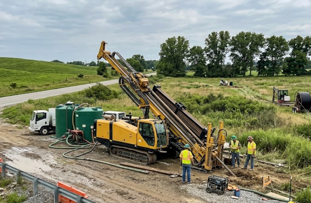
Eddy County's shallow stack — Xcel Energy secondary, carrier fiber, city water, gas gathering lines, and brine-infrastructure easements — means Carlsbad HDD starts with New Mexico 811 and hand holes at paint conflicts. Directional Boring New Mexico matches rig class to Pecos River alluvium versus gypsum mesa fill, not a Hobbs open-desert template.
Directional boring in Carlsbad on US-285 and National Parks Highway frontage layers NMDOT District 2 MOT, city ROW fees, and Pecos floodplain awareness on standard locate rules. Potash-service industrial growth adds night-window bores when daytime traffic on Canal cannot stop.
Real Eddy County angles — not generic statewide copy.
Post-paving TI cannot trench across the parking aisle to reach switchgear. HDD links vaults with pits offset from striping.
Failed lateral under rock mulch and stucco walls — steerable bore from meter to cleanout preserves the courtyard open-cut would remove.
NMDOT widening stacks relocations under state ROW. HDD narrows lane closure versus open trench; night windows scoped before booking.
Mine-adjacent ROW with shallow brine-infrastructure congestion — compact rig for short vault shot with enhanced pothole program.
Carlsbad HDD crews confirm survey and locate paint — two business days minimum on 811, longer when NMDOT or Pecos floodplain controls the ROW. Pits are shored for gypsum fill or river alluvium; mud weight rises near Pecos bank parcels. Pilot, ream, and pullback are monitored for buoyancy on long HDPE pulls through flood-softened fill.
Eddy County Delaware Basin fringe carries gypsum-rich soil, caliche hardpan, and Pecos River alluvium — potash-mine grading debris and brine-infrastructure proximity change mud programs mile to mile.
Carlsbad bores encounter gypsum-rich sandy loam on mesa parcels with caliche hardpan between 2 and 8 feet — similar to Roswell valley fill but with more Pecos River alluvium near the watercourse. Potash-mine service corridors can hide grading cobbles and brine-infrastructure debris that potholing catches before pits are sized. River-adjacent paths carry higher groundwater after Pecos flood stages and monsoon storms — buoyancy management matters on longer HDPE pulls. We do not assume Hobbs open-desert models apply along the Pecos corridor.
Pecos River valley heat, spring wind, and summer monsoons drive Carlsbad bore schedules — river-adjacent groundwater and potash-brine corridor awareness are built into quotes.
Summer heat above 100°F affects crew safety and fluid performance on exposed valley pads. Pecos River flood stages in spring and monsoon cloudbursts from July through September raise river-adjacent groundwater — entry pit work may wait for stable conditions. Spring wind complicates cage handling on open US-285 sites. We schedule around known flood patterns instead of forcing bores into saturated Pecos bank fill.
City of Carlsbad Community Development, Eddy County ROW, NMDOT District 2 on US-285 and US-62, Pecos River floodplain, potash operator easements, and Xcel Energy agreements apply on many alignments.
City of Carlsbad Community Development governs street cuts, driveway removals, and flood-control work along the Pecos River and municipal drainage. Eddy County ROW applies on unincorporated parcels toward Loving and the Caverns approach. NMDOT District 2 controls US-285, US-62, and National Parks Highway bores — MOT plans are common on Canal Street frontage. Pecos River floodplain review adds environmental hold points beyond standard 811. Potash operator and brine-infrastructure easements govern mine-adjacent paths. Xcel Energy agreements apply on electric-adjacent corridors.
Open-cut on North Carlsbad hardscape or Canal retail pads often costs more in gravel mulch and business interruption than the bore. HDD wins on US-285 congestion and Pecos easements — open valley acreage may still favor trench on price.
Footage, diameter, caliche versus rock, dewatering, traffic control, permit fees, utility density, and rig class — quoted as drivers, not a menu price.
You share plans or describe the problem; we confirm alignment, depth, access, and which trenchless method fits New Mexico soils.
New Mexico 811 ticket filed; two business days minimum before pits open unless your permit path differs. We pothole where marks conflict.
Bore plan, NMDOT or city ROW permits, railroad agreements, and crossing engineering when the path leaves private property.
Compact spread for tight Santa Fe lots; larger HDD for I-25 or I-40 relocations — matched to length and diameter.
Steered pilot on design line, ream passes sized for your pipe or casing, fluid program tuned for caliche or adobe clay.
HDPE fusion, steel casing, or multi-duct bundle pulled with tension and bend-radius monitoring.
Pressure test, mandrel, or survey records for owners, inspectors, and operators as spec requires.
Compact pits, replace gravel or hardscape per scope, leave 811 ticket and locate map in your project file.
Carlsbad HDD follows length, diameter, gypsum or river alluvium, utility density, potash easements, and restoration — not a flat rate. North Carlsbad lateral, Canal duct, and US-285 crossing use different spreads. Send alignment for a free estimate.
Yes — mud programs adjust for gypsum-rich fill and river-adjacent sand. Pecos flood stages and monsoon groundwater need extra planning on long pulls.
Two business days minimum after 811 filing. Older Canal Street and potash-corridor paths often need remark tickets and potholes at abandoned lines.
Yes — daily mobilization across Eddy County; permitting shifts between city, county, and operator easements.
Often yes with offset pits and steerable path — tie-in cuts flagged in quote.
24/7 — Emergency dispatch statewide. Tell us entry, exit, pipe size, and county — a bore specialist calls back with cost drivers, not a flat rate.
Scope your alignment
Step 1 of 2 — path, pipe, and city first