NM-528 trunk relocation near Unser interchange
NMDOT MOT and night windows — permit lead exceeds bore duration.
Rio Rancho, NM · Sandoval County
Rio Rancho highway and arroyo crossings on NM-528, Unser, and west-mesa drainage — long-span HDD when open cut fails NMDOT and flood-control review.
River, highway, and railroad crossings in Rio Rancho are where trenchless is default — NMDOT District 3 relocations on NM-528 and Unser, arroyo flood-control structures, and PNM transmission easements rarely justify open cut against engineered bore plans.
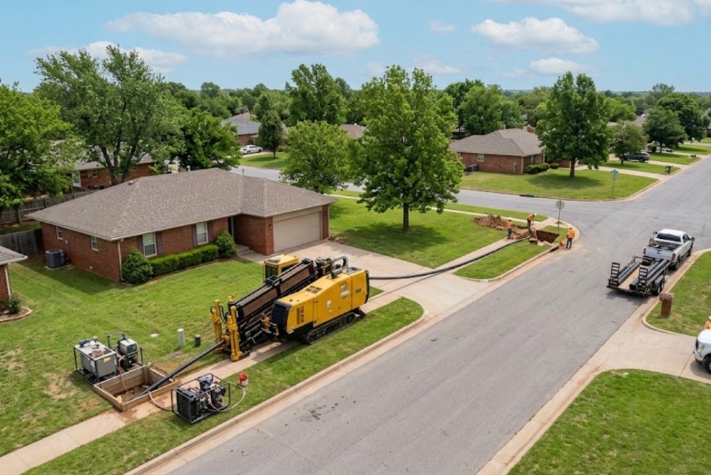
Directional boring at crossing scale means larger spreads, staged reaming, and agency calendars starting months before drill day. Night MOT and environmental windows set the schedule.
Municipal trunks, telecom backbones, and electric feeders share corridor headaches — multiple utilities in one casing need engineered dividers, not ad hoc bundling.
Real Sandoval County angles — not generic statewide copy.
NMDOT MOT and night windows — permit lead exceeds bore duration.
Drainage easement and bank stability — HDD avoids open cut through municipal trail systems.
Operator and railroad templates with flagging and inspection — HDD or jack per agreement.
NMDOT permits — long shot with staged ream and survey closeout.
Rio Rancho crossing work starts with engineered profile and controlling permit — NMDOT or flood-control authority leads beyond standard 811. Larger rigs with mud plants and pullback monitoring; as-built survey before restoration.
Sandoval County mesa tops carry volcanic basalt, caliche crust, and fractured tuff — arroyo cuts expose sandy fill that changes mud programs block to block.
Rio Rancho bores hit caliche crust between 2 and 6 feet on mesa tops, then volcanic basalt or fractured tuff depending on distance from arroyo cuts. Paseo del Volcan and west infill can expose cobble lenses from old grading that stall reaming without test pits. Arroyo-adjacent parcels carry sandy fill with higher groundwater after monsoon runoff — buoyancy management matters on longer HDPE pulls. We do not assume bosque sand models from east Albuquerque apply on the west mesa.
West-mesa wind, spring dust, and monsoon runoff through arroyos shape Rio Rancho bore schedules — lightning holds and post-storm soft ROW are built into quotes.
Monsoon season from July through September softens arroyo banks and can delay entry pits on sandy fill. Spring wind on exposed mesa pads affects cage and fluid handling along Unser and Paseo del Volcan. Winter cold at mesa elevation slows morning startup but rarely stops work — we communicate when dry conditions matter for caliche-heavy pits rather than risk frac-outs toward arroyo channels.
City of Rio Rancho Community Development, Sandoval County ROW, NMDOT District 3 on NM-528, Santa Ana Pueblo coordination, and PNM easements apply on many alignments.
City of Rio Rancho Community Development governs street cuts, driveway removals, and flood-control work along municipal arroyos. Sandoval County ROW applies on unincorporated pockets toward Corrales and the north mesa. NMDOT District 3 controls NM-528 and I-25 access ramps — MOT plans are common on Southern Boulevard frontage. Santa Ana Pueblo coordination may apply on parcels near tribal boundaries. PNM easement agreements add hold points on transmission-adjacent paths.
Major crossings rarely justify open cut — detour and arroyo easement impact favor trenchless once alignment is approved.
Length, diameter, groundwater, environmental windows, flagging, engineering, inspection.
You share plans or describe the problem; we confirm alignment, depth, access, and which trenchless method fits New Mexico soils.
New Mexico 811 ticket filed; two business days minimum before pits open unless your permit path differs. We pothole where marks conflict.
Bore plan, NMDOT or city ROW permits, railroad agreements, and crossing engineering when the path leaves private property.
Compact spread for tight Santa Fe lots; larger HDD for I-25 or I-40 relocations — matched to length and diameter.
Steered pilot on design line, ream passes sized for your pipe or casing, fluid program tuned for caliche or adobe clay.
HDPE fusion, steel casing, or multi-duct bundle pulled with tension and bend-radius monitoring.
Pressure test, mandrel, or survey records for owners, inspectors, and operators as spec requires.
Compact pits, replace gravel or hardscape per scope, leave 811 ticket and locate map in your project file.
Weeks-to-months depending on district and scope — permits before drill date.
Possible with engineered dividers per owner spec — not improvised bundling.
Rio Puerco drainage, municipal arroyos, and flood-control channels each carry different easement rules.
Yes — operator and railroad templates with flagging; agreements often set critical path.
Length, diameter, MOT, and inspection drive price — engineered quotes only.
24/7 — Emergency dispatch statewide. Tell us entry, exit, pipe size, and county — a bore specialist calls back with cost drivers, not a flat rate.
Scope your alignment
Step 1 of 2 — path, pipe, and city first